September 19, 2013

List of Districts of Lakshadweep

  • Lakshadweep
    Indian union territory
  • Lakshadweep 120 to 270 mi) off the south western coast of India. The archipelago is a Union Territory and is governed by the Union Government of India.  Lakshadweep comes from "Lakshadweepa", which means "one hundred thousand islands" in Sanskrit as well as many Indian languages like Hindi, Malayalam, Kannada, Telugu and others.

    Capital : Kavaratt                                     Population (2011) : 64,429

    Largest city: Andrott                               Districts : 1

    Official languages : Malayalam, English,Mahl (Dhivehi) is spoken on Minicoy Island

     Area : 32 km2 (12 sq mi)                     Website : www.lakshadweep.gov.in

    Coordinates: 10.57°N 72.63°E           Time zone : IST (UTC+05:30)
  • List of Districts of Chandigarh

  • Chandigarh
    City in India
  • Chandigarh is a city and union territory in India that serves as the capital of two states, Haryana and Punjab. The name Chandigarh translates as "The Fort of Chandi". 

    The city of Chandigarh was the first planned city in India post independence in 1947 (pre-independence planned cities include Dispur in Assam, New Delhi in DelhiJaipur in Rajasthan, etc.) and is known internationally for its architecture and urban design.The city tops the list ofIndian States and Union Territories with the highest per capita income in the country at INR99262 (US$1,500) at current prices. The city was reported in 2010 to be the "cleanest" in India, based on a national government study, and the territory also headed the list of Indian states and territories according to research conducted using 2005 data by Human Development Index.

    Seat of Government : Chandigarh                Population (2011) : 960,787

    Official languages : Punjabi                          Literacy :  81.9%

    Area : 114 km2 (44 sq mi)                             Website : chandigarh.nic.in

    Coordinates: 30.75°N 76.78°E                   Time zone : IST (UTC+05:30)
  • September 18, 2013

    List of Districts of Daman and Diu


  • Daman and Diu
    Indian union territory
  • Daman and Diu is a union territory in India. 
    According to the Constitution of India, Administration of Daman and Diu is carried out by an Administrator appointed by President of India.
    Capital : Daman                                     Population (2011) : 242,911

    Districts : 2                                             Official languages : English, Gujarati, Hindi, Marathi

    Area : 102 km2 (39 sq mi)                    Website : http://daman.nic.in


    Coordinates: 20.42°N 72.83°E          Time zone : IST (UTC+05:30)

    Districts

    • Diu District, an area of 40 km². The main settlement is the town of Diu.
    • Daman District, an area of 28 sq mi or 72 km². The main settlement is the city of Daman.
  • List of Districts of Andaman and Nicobar Islands


  • Andaman and Nicobar Islands
    Indian union territory

  • The Andaman and Nicobar Islands are a group of islands at the juncture of the Bay of Bengal and Andaman Sea, and are a Union Territory of India.
    The territory is 150 km (93 mi) north of Aceh in Indonesia and separated from Thailand and Burma by the Andaman Sea. It comprises two island groups, the Andaman Islands and the Nicobar Islands, separated by the 10° N parallel, with the Andamans to the north of this latitude, and the Nicobars to the south. The Andaman Sea lies to the east and the Bay of Bengal to the west.
    The territory's capital is the Andamanese town of Port Blair. The total land area of the territory is approximately 8,073 km2 (3,117 sq mi). The capital of Nicobar Islands is Car Nicobar also known as Malacca.

    Capital : Port Blair                                                    Population (2011) : 380,500

    Largest city : Port Blair                                           Literacy  : 

    Districts : 3                                                               Official languages : Hindi and English

    Area : 8,073 km2 (3,117 sq mi)                              Website : www.and.nic.in

    Coordinates (Port Blair): 11.68°N 92.77°E          Time zone : IST (UTC+05:30)


          Districts of Andaman and Nicobar Islands


  • List of Districts of Mizoram


  • Mizoram
    Indian state

  • Mizoram is one of the Seven Sister States of the North Eastern India, sharing borders with the states of Tripura, Assam, Manipur and with the neighbouring countries of Bangladesh and Burma. Mizoram became the 23rd state of India on 20 February 1987.  Its capital is Aizawl.

    Capital : Aizawl                                                    Population (2011) : 1,091,014

    Largest city : Aizawl                                           Literacy  : 91.58%

    Districts : 8                                                          Official languages : Mizo

    Area : 21,081 km2 (8,139 sq mi)                       Website : mizoram.gov.in

    Coordinates (Aizawl): 23.36°N 92.0°E           Time zone : IST (UTC+05:30)


    AIZAWL                             KOLASIB   


    CHAMPHAI                       MAMMIT  

    LUNGLEI                            LAWNGTLAI


     SAIHA                                SERCHHIP


  • September 16, 2013

    List of Districts of Jharkhand

    Jharkhand

  • Indian state


  • Jharkhand is a state in eastern India. It was carved out of the southern part of Bihar on 15 November 2000. Jharkhand shares its border with the states of Bihar to the north, Uttar Pradesh and Chhattisgarh to the west, Odisha to the south, and West Bengal to the east. It has an area of 30,778 sq mi (79,710 km2). The industrial city of Ranchi is its capital and Dumka is sub capital while Jamshedpur is the largest and the biggest industrial city of the state. Some of the other major cities and industrial centres are DhanbadBokaro and Hazaribagh.
    The name "Jharkhand" means "The Land of Forests". In regional language meaning of Jhar is Gold, so meaning of Jharkhand is "Piece of Gold". Jharkhand is famous for its rich mineral resources like Uranium, Mica, Bauxite, Granite, Gold, Silver, Graphite, Magnetite, Dolomite, Fireclay, Quartz, Fieldspar, Coal (32% of India), Iron, Copper (25%of India) etc. Forests and woodlands occupy more than 29% of the state which is amongst the highest in India.

    Capital : Ranchi                                                    Population (2011) : 32,988,134

    Largest city : Jamshedpur                                 Literacy  : 67.6%

    Districts : 24                                                          

    Official languages : Hindi, Santhali, Mundari, Oriya, HO, Kurukh

    Area : 79,714 km2 (30,778 sq mi)                                Website : www.jharkhand.gov.in

    Coordinates (Ranchi Patna): 23.35°N 85.33°E         Time zone : IST (UTC+05:30)

  • List of Districts of Tripura


  • Tripura
    Indian state

  • Tripura is a state in North East India. The third-smallest state in the country, it covers 10,491 km² and is bordered by Bangladesh to the north, south, and west, and the Indian states of Assam and Mizoram to the east.

    Tripura lies in a geographically disadvantageous location in India, as only one major highway, the National Highway 44, connects it with the rest of the country.
     Five mountain ranges—BoromuraAtharamuraLongtharaiShakhan and Jampui Hills—run north to south, with intervening valleys;Agartala, the capital, is located on a plain to the west. The state has a tropical savanna climate, and receives seasonal heavy rains from the south west monsoon

    Capital : Agartala                                                    Population (2011) : 3,671,032

    Most populous city : Agartala                             Literacy  : 94.65 %

    Districts : 8                                                             Official languages : Bengali and Kokborok

    Area : 10,491.69 km2 (4,050.86 sq mi)                Website tripura.gov.in


    Coordinates (Agartala): 23.84°N 91.28°E         Time zone : IST (UTC+05:30)


  • List of Districts of Uttarakhand

    Uttarakhand

  • Indian state
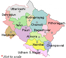
  • Uttarakhand, formerly Uttaranchal, is a state in the northern part of India. It is often referred to as the "Land of the Gods" due to the many holy Hindu temples and pilgrimage centres found throughout the state. Uttarakhand is mainly known for its natural beauty of the Himalayas, the Bhabhar and the TeraiIt borders the Tibet Autonomous Region on the north; the Mahakali Zone of the Far-Western RegionNepal on the east; and the Indian states of Uttar Pradesh to the south and Himachal Pradesh to the northwest. The state is divided into two divisions, Garhwal and Kumaon, with a total of 13 districts. The provisional capital of Uttarakhand is Dehradun, the largest city in the region, which is a railhead. The high court of the state is in Nainital.

  • Two of the most important rivers in Hinduism originate in the region, the Ganga at Gangotri and the Yamuna at Yamunotri. These two along with Badrinath and Kedarnath form the Chota Char Dham, a holy pilgrimage for the Hindus. The state hosts the Bengal tiger in Jim Corbett National Park, the oldest national park of the Indian subcontinent. The Valley of Flowers, a Unesco World Heritage Site located here, is known for the variety and rarity of the flowers and plants found there.

    Capital : Dehradun                                                    Population (2011) : 10,116,752

    Largest city : Dehradun                                          Literacy  : 79.63%

    Districts : 13                                                             Official languages : Hindi, Sanskrit

    Area : 51,125 km2 (19,739 sq mi)                          Websiteuttara.gov.in

    Coordinates (Dehradun): 30.33°N 78.06°E         Time zone : IST (UTC+05:30)


    Division - wise Districts in Uttarakhand
    ·           Garhwal Division
    o    Dehradun
    o    Haridwar
    o    Chamoli
    o    Rudraprayag
    o    Tehri Garhwal
    o    Uttarkashi
    o    Pauri Garhwal
    ·         Kumaoun Division
    o    Almora
    o    Nainital
    o    Pithoragarh
    o    U S Nagar
    o    Bageshwar
    o    Champawat


  • Uttarakhand Uttarkashi Dehradun Haridwar Tehri rudraprayag chamoli pauri bageshwar pithoragarh almora nainital  champawat usnagar