September 12, 2013

List of Districts of Delhi

  • Delhi
    Indian union territory
  • Delhi is a metropolitan region in India that includes the national capital city, New Delhi. It is India's second-most-populous city after Mumbai, and the largest city in terms of area.
    With a population of 22 million in 2011, the city is the fourth-largest city in the world. The NCT and its urban region have been given the special status of National Capital Region (NCR) under the Constitution of India's 69th amendment act of 1991. The NCR includes the neighbouring cities of Baghpat, Gurgaon, Sonepat, Faridabad, Ghaziabad, Noida, Greater Noida and other nearby towns, and has nearly 22.2 million residents.

    Capital : New Delhi                                              Population (2011) : 12,565,901

    Districts : 11 total                                                Ethnicity : Hindi, Punjabi, Bihari

    Area : 1,484.0 km2 (573.0 sq mi)                      Website : delhi.gov.in

    Coordinates: 28°36′36″N 77°13′48″E             Time zone : IST (UTC+05:30)

  • September 11, 2013

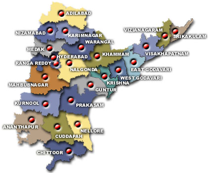
    Districts of Andhra Pradesh


    Andhra Pradesh


    Capital: Hyderabad Population (2011) : 84,655,533

    Largest city: Hyderabad Literacy : 67.77%

    Districts : 23 total Official languages : Telugu

    Area : 275,045 km2 (106,195 sq mi) Website : www.aponline.gov.in

    Coordinates (Hyderabad): 17.366°N 78.476°E Time zone : IST (UTC+05:30)


    Districts of Andhrapradesh


                                             ANDHRAPRADESH DISTRICT MAP
    Andhrapradesh District Map


    List of districts of India

    India

    India (Bharat), is a Union of States and is a country in South Asia. It is the seventh-largest country by area, the second-most populous country with over 1.22 billion people, and the most populous democracy in the world.

    Capital: New DelhiDistricts(2011) : 640 total

    Largest city: MumbaiOfficial languages: Hindi, English    

    Population: 1.237 billion (2012) World Bank States : 35 (28 states +7 UT)

    President: Pranab MukherjeePrime Minister: Dr. Manmohan Singh

    Currency : Indian rupee (Indian Rupee Symbol) (INR)Website : india.gov.in

    Government: Federal republic, Constitutional republic, Parliamentary system


                                  States Of India

     UNION TERRITORIES OF INDIA


    A district (Zilla) is an administrative division of an Indian state or territory.There are 671 districts in India now. There were a total of 640 districts in India in 2011. Twenty Eight States and Seven Union Territories span the length and breadth of the Country, marked by diversity in culture and geography but bound together by a common chord of Nationalism. Districts in India are administered by their respective State/UT Government.

    List of Districts of Goa


  • Goa
    Indian state

    Goa is India's smallest state by area and the fourth smallest by population. Located in West India in the region known as the Konkan, it is bounded by the state of Maharashtra to the north, and by Karnataka to the east and south, while the Arabian Sea forms its western coast. Goa is India's richest state with a GDP per capita two and a half times that of the country as a whole.

    It was ranked the best placed state by the Eleventh Finance Commission for its infrastructure and ranked on top for the best quality of life in India by the National Commission on Population based on the 12 Indicators.
    Panaji is the state's capital, while Vasco da Gama is the largest city. Renowned for its beaches, places of worship and world heritage architecture, Goa is visited by large numbers of international and domestic tourists each year. It also has rich flora and fauna, owing to its location on the Western Ghats range, which is classified as a biodiversity hotspot.

    Capital : Panaji                                                             Population (2011) : 1,457,723

    Largest city : Vasco da Gama                                 Literacy : 87%

    Districts : 2                                                                  Official languages : Konkani

    Area : 3,702 sq Km (1,429 sq mi)                             Website : www.goa.gov.in

    Coordinates (Panaji): 15°29′56″N 73°49′40″E     Time zone : IST (UTC+05:30)


    Districts of Goa


  • List of Districts of Madhya Pradesh

    Madhya Pradesh
    Indian state

    Madhya Pradesh is a state in central India. Its capital is Bhopal, and the largest city is Indore. Nicknamed the "heart of India" due to its geographical location in India, Madhya Pradesh is the second largest state in the country by area. With over 75 million inhabitants, it is the sixth largest state in India by population. It borders the states of Uttar Pradesh to the northeast, Chhattisgarh to the southeast, Maharashtra to the south, Gujarat to the west, and Rajasthan to the northwest.


  • Capital : Bhopal                                               Population: (2011) : 72,597,565

    Largest city : Indore                                        Literacy  : 70.60% (2011)

    Districts : 50                                                    Official languages : Hindi

    Area : 308,252 km2 (119,017 sq mi)            Website : mp.gov.in / www.mp.nic.in

    Coordinates : 23.25°N 77.417°E                 Time zone : IST (UTC+05:30)


           Districts of Madhya Pradesh      


    1. Alirajpur11. Chhindwara21. Indore31. Neemuch41.Singrauli
    2. Anuppur12. Damoh22. Jabalpur32. Panna42. Shahdol
    3. Ashoknagar13. Datia23.Jhabua33. Raisen43. Shajapur
    4. Balaghat14. Dewas24. Katni34. Rajgarh44. Sheopur
    5. Barwani15. Dhar25. Khandwa35. Ratlam45. Shivpuri
    6. Betul16. Dindori26. Khargone36. Rewa46. Sidhi
    7. Bhind17. Guna27. Mandla37. Sagar47. Tikamgarh
    8. Bhopal 18. Gwalior28. Mandsaur38. Satna48. Ujjain
    9. Burhanpur19. Harda29. Morena39. Sehore49. Umaria
    10. Chhatarpur20. Hoshangabad30. Narsinghpur40. Seoni50. Vidisha


                                District Map of Madhya Pradesh

  • Barwani  Khargone  Burhanpur Khandwa  Harda Betul  Balaghat Mandla  Anuppur  Dhar Indore Jhabua Dewas Sehore Hoshangabad Narsinghpur Ratlam  Ujjain Mandsaur Neemuch Shajapur Rajgarh  Raisen Guna  Vidisha Sagar Damoh Panna Jabalpur Katni Umaria Shahdol Sidhi  Rewa  Satna Chhatarpur Ashoknagar  Shivpuri Sheopur Morena Bhind  Gwalior  Datia Singrauli  Alirajpur

    List of Districts of Assam

    Assam
    Indian state


  • Assam is a northeastern state of India. Its capital is Dispur, located within the municipal area of Guwahati city. Located south of the eastern Himalayas, Assam comprises the Brahmaputra and the Barak river valleys along with the Karbi Anglong and the North Cachar Hills with an area of 30,285 square miles (78,438 km²). 
    Assam is surrounded by six of the other Seven Sister States: Arunachal Pradesh, Nagaland, Manipur, Mizoram, Tripura and Meghalaya. Geographically Assam and these states are connected to the rest of India via a narrow strip of land in West Bengal called the Siliguri Corridor or "Chicken's Neck".

    Capital : Dispur                                                 Population (2011) : 31,169,272
    Largest city : Dispur                                        Literacy  : 73.18%

    Districts : 27                                                      

    Official languages : Assamese,Bengali (in Barak Valley),Bodo (in Bodoland)

    Area : 78,550 km2 (30,330 sq mi)                     Website : assam.gov.in

    Coordinates (Dispur): 26.14°N 91.77°E         Time zone : IST (UTC+05:30)


                        Assam Districts